Johor Bahru (Johor Bahru)
 |
Johor Bahru was founded in 1855 as Tanjung Puteri when the Sultanate of Johor came under the influence of Temenggong Daeng Ibrahim. The area was renamed "Johore Bahru" in 1862 and became the capital of the Sultanate when the Sultanate administration centre was moved there from Telok Blangah, which is today located within southern Singapore.
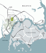
Johor Bahru serves as one of the two land border connections on the Malaysian side between the countries of Singapore and Malaysia, the other being the Second Link that links Iskandar Puteri to Tuas. It is the busiest international border crossing in the world; its direct land link to Woodlands, Singapore through the causeway is a key economic driver of the border city. Johor Bahru is categorised as Zone A of Iskandar Malaysia and is adjacent to Senai International Airport and the 15th busiest port in the world, Port of Tanjung Pelepas.
During the reign of Sultan Abu Bakar, there was further development and modernisation within the city; with the construction of administrative buildings, schools, religious buildings, and railways connecting to Woodlands in Singapore. Along with most of Southeast Asia, Japanese forces occupied Johor Bahru from 1942 to 1945 during the Pacific War. Johor Bahru became the cradle of Malay nationalism after the war and a major political party known as the United Malays National Organisation (UMNO) was founded at the Istana Besar of Johor Bahru in 1946. After the formation of Malaysia in 1963, Johor Bahru retained its status as state capital and was granted city status in 1994. Today, it is one of the most developed cities in the nation and currently serves as the financial centre and logistics hub of southern Malaysia.
The present area of Johor Bahru was originally known as Tanjung Puteri, and was a fishing village of the Malays. Temenggong Daeng Ibrahim then renamed Tanjung Puteri to Iskandar Puteri once he arrived in the area in 1858 after acquiring the territory from Sultan Ali; before it was renamed Johor Bahru by Sultan Abu Bakar following the Temenggong's death. (The suffix "Bah(a)ru" means "new" in Malay, normally written "baru" in standard spelling today but appearing with several variants in place names, such as Kota Bharu and Indonesian Pekanbaru.) The British preferred to spell its name as Johore Bahru or Johore Bharu, but the current accepted western spelling is Johor Bahru, as Johore is only spelt Johor (without the letter "e" at the end of the word) in the Malay language. The city is also spelt as Johor Baru or Johor Baharu.
The city was also once known as "Little Swatow (Shantou)" by the Chinese community in Johor Bahru, as most of Johor Bahru's Chinese residents are Teochew people whose ancestry can be traced back to Shantou, China. They arrived in the mid 19th century, during the reign of Temenggong Daeng Ibrahim. The city, however, is generally known in Chinese as Xinshan meaning "New Mountain" as "mountain" may be used to mean "territory" or "land", and the name "New Mountain" distinguished it from the "Old Mountain" (Jiushan) once used to refer to Kranji and Sembawang in Singapore on the opposite side of the Straits of Johor, where Chinese first cultivated pepper and gambier in plantations before the Chinese moved to new land in Johor Bahru to create new plantations in 1855.
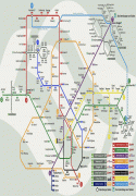
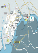
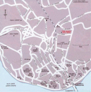
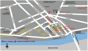
Map - Johor Bahru (Johor Bahru)
Map


Country - Malaysia
 |
 |
| Flag of Malaysia | |
Malaysia has its origins in the Malay kingdoms, which, from the 18th century on, became subject to the British Empire, along with the British Straits Settlements protectorate. Peninsular Malaysia was unified as the Malayan Union in 1946. Malaya was restructured as the Federation of Malaya in 1948 and achieved independence on 31 August 1957. The independent Malaya united with the then British crown colonies of North Borneo, Sarawak, and Singapore on 16 September 1963 to become Malaysia. In August 1965, Singapore was expelled from the federation and became a separate independent country.
Currency / Language
| ISO | Currency | Symbol | Significant figures |
|---|---|---|---|
| MYR | Malaysian ringgit | RM | 2 |
| ISO | Language |
|---|---|
| ZH | Chinese language |
| EN | English language |
| MS | Malay language |
| ML | Malayalam language |
| PA | Panjabi language |
| TA | Tamil language |
| TE | Telugu language |
| TH | Thai language |